This indispensable, user-friendly GPS handheld with touchscreen comes with preloaded TopoActive maps featuring routable trails and roads for your outdoor adventures. Thanks to the durable design and long battery life, you can enjoy your activities even longer.
✔️ Swipe and zoom on a bright 3″ touchscreen
✔️ Preloaded maps for roads and trails
✔️ Long battery life up to 130 hours in GPS mode
✔️ Plan and review trips with the Garmin Explore™ smartphone app
✔️ Rugged design (MIL-STD 810) and weather-resistant (IP67)
✔️ Option for Outdoor Maps+ subscription for premium maps
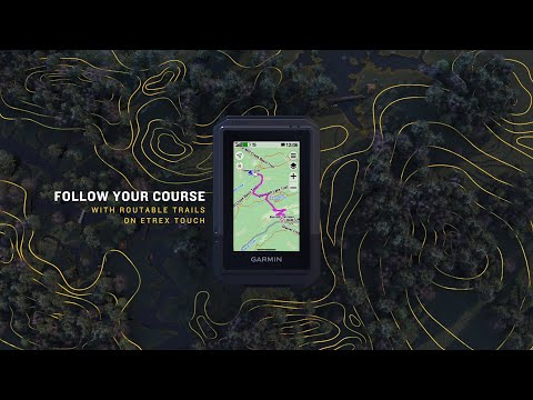
The slim, pocket-sized handheld features a bright 3″ high-resolution color touchscreen, making it easy to swipe and zoom to follow your route.
The eTrex Touch handheld is specially built with an IP67 water-resistant and shockproof (MIL-STD-810) design that can withstand harsh conditions and tough adventures.
View detailed TopoActive maps with routable roads and trails, terrain contours, elevations, peaks, parks, rivers, lakes, and thousands of points of interest. You also have easy access to additional TopoActive maps worldwide.
Purchase an Outdoor Maps+ subscription for continuous access to premium mapping content, including satellite imagery and campsites. Download and receive automatic updates via Wi-Fi®.
Pair your device with the Garmin Explore App to plan and review trip data on your smartphone or tablet and manage your waypoints, courses, and activities.
Get real-time weather updates so you’re always prepared for changing conditions. This function requires an internet or Wi-Fi connection, or the Garmin Explore app on your paired smartphone.
General
Lens: Chemically hardened glass
Dimensions: 66 mm x 105.4 mm x 24.6 mm (2.6″ x 4.15″ x 0.97″)
Weight: 150 g (5.3 oz)
Water rating: IP67
Touchscreen: Yes
Display type: 3″ transflective TFT color display
Display size: 3.88 cm x 6.48 cm (1.53″ x 2.55″); diagonal 7.62 cm (3″)
Resolution: 240 x 400 pixels
Battery type: Rechargeable internal lithium-ion
Battery life: Up to 130 hrs (all satellite systems + multi-band)*
Expedition mode: up to 650 hrs
*With SatIQ technology under typical use
Memory/history: 32 GB (user space varies with preloaded maps)
Interface: USB-C
Maps & Memory
Preloaded maps: Yes (TopoActive, routable)
Add maps: Yes
Basemap: Yes
Turn-by-turn road navigation: Yes
Map segments: 15,000
Satellite imagery: Yes (via Outdoor Maps+ subscription)
Hydrographic features: Yes
Points of interest: Yes
Parks & wilderness areas: Yes
Waypoints: Yes
Courses: Unlimited
Activities: Unlimited
Activity profiles: Yes
GPX imports: Yes
Sensors
GPS: Yes
GLONASS: Yes
Galileo: Yes
QZSS: Yes
BeiDou: Yes
IRNSS: Yes
Barometric altimeter: Yes
Compass: Yes
High-sensitivity receiver: Yes
GPS compass (while moving): Yes
Multi-band frequency: Yes
Smart features
Connect IQ™: Yes
Smartphone notifications: Yes
Weather: Yes
Garmin Connect™ Mobile: Yes
Garmin Share: Yes
Passcode: Yes
Predictive text / autocorrect: Yes
Safety & tracking
LiveTrack: Yes
Tactical features
Compatible with AB Synapse: Yes
Ballistics calculator: Yes (requires unlock)
Dual grid coordinates: Yes
Night vision mode: Yes
Outdoor recreation features
Point-to-point navigation: Yes
TracBack®: Yes
Area calculation: Yes
Sun & moon data: Yes
Geocaching Live: Yes
Custom maps: Yes (500 tiles)
Photo viewer: Yes
Outdoor apps
Compatible with Garmin Explore™ app: Yes
Compatible with Garmin Explore website: Yes
Connectivity
Wireless: Yes (Wi-Fi®, BLE, ANT®)
No reviews yet
What do you think of the article?