
€229.00
Home
Top Sellers

New Products


Multi-band technology and expanded GNSS support (GPS, GLONASS, Galileo, QZSS and IRNSS) provide optimal accuracy in steep country, urban canyons and forests with dense trees.
Navigate every trail with ABC sensors, including an altimeter for elevation data, barometer to monitor weather and 3-axis electronic compass.
Download high-resolution photo-realistic maps directly to your device without an annual subscription. Easily find trails, pick stand locations, find parking, create waypoints and more.
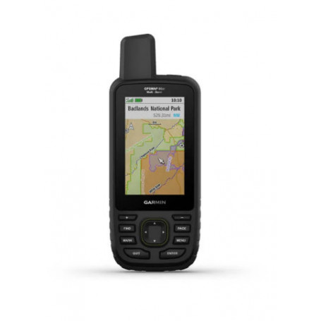
Preloaded TopoActive U.S. and Canada maps show you terrain contours, topographic elevations, summits, parks, coastlines, rivers, lakes and geographical points.
Optional display of federal public land boundaries on topographical maps helps you know that you’re venturing where you’re supposed to be.
When paired with your compatible smartphone, you can get real-time forecast information and live weather radar, so you’re aware of the surrounding conditions.
General |
|
| PHYSICAL DIMENSIONS | 2.5" x 6.4" x 1.4" (6.2 x 16.3 x 3.5 cm) |
|---|---|
| DISPLAY SIZE | 1.5"W x 2.5"H (3.8 x 6.3 cm); 3" diag (7.6 cm) |
| DISPLAY RESOLUTION | 240 x 400 pixels |
| DISPLAY TYPE | transflective color TFT |
| WEIGHT |
8.1 oz (230 g) with batteries |
| BATTERY TYPE | Rechargeable, internal lithium-ion |
| BATTERY LIFE |
Up to 36 hours |
| WATER RATING | IPX7 |
| MIL-STD-810 | yes (thermal, shock, water) |
| HIGH-SENSITIVITY RECEIVER | yes |
| INTERFACE | high speed micro USB and NMEA 0183 compatible |
| MEMORY/HISTORY | 16 GB (user space varies based on included mapping) |
Maps & Memory |
|
| PRELOADED MAPS |
yes (TopoActive; routable) |
|---|---|
| ABILITY TO ADD MAPS | yes |
| BASEMAP | yes |
| AUTOMATIC ROUTING (TURN BY TURN ROUTING ON ROADS) | yes |
| MAP SEGMENTS | 15000 |
| BIRDSEYE | yes (direct to device) |
| INCLUDES DETAILED HYDROGRAPHIC FEATURES (COASTLINES, LAKE/RIVER SHORELINES, WETLANDS AND PERENNIAL AND SEASONAL STREAMS) | yes |
| INCLUDES SEARCHABLE POINTS OF INTERESTS (PARKS, CAMPGROUNDS, SCENIC LOOKOUTS AND PICNIC SITES) | yes |
| DISPLAYS NATIONAL, STATE AND LOCAL PARKS, FORESTS, AND WILDERNESS AREAS | yes |
| EXTERNAL MEMORY STORAGE | yes (32 GB max microSD™ card) |
| WAYPOINTS/FAVORITES/LOCATIONS | 10000 |
| TRACKS | 250 |
| TRACK LOG | 20000 points, 250 saved gpx tracks, 300 saved fit activities |
| ROUTES | 250, 250 points per route; 50 points auto routing |
| RINEX LOGGING | yes |
Sensors |
|
| GPS | yes |
|---|---|
| GLONASS | yes |
| GALILEO | yes |
| BAROMETRIC ALTIMETER | yes |
| COMPASS | Yes (tilt-compensated 3-axis) |
| GPS COMPASS (WHILE MOVING) | yes |
Daily Smart Features |
|
| CONNECT IQ™ (DOWNLOADABLE WATCH FACES, DATA FIELDS, WIDGETS AND APPS) | yes |
|---|---|
| VIRB® REMOTE | yes |
| PAIRS WITH GARMIN CONNECT™ MOBILE | yes |
| ACTIVE WEATHER | yes |
| SMART NOTIFICATIONS ON HANDHELD | yes |
Safety and Tracking Features |
|
| LIVETRACK | yes |
|---|---|
Outdoor Recreation |
|
| POINT-TO-POINT NAVIGATION | yes |
|---|---|
| COMPATIBLE WITH BASECAMP™ | yes |
| AREA CALCULATION | yes |
| HUNT/FISH CALENDAR | yes |
| SUN AND MOON INFORMATION | yes |
| XERO™ LOCATIONS | yes |
| GEOCACHING-FRIENDLY | yes (Geocache Live) |
| CUSTOM MAPS COMPATIBLE | yes (500 custom map tiles) |
| PICTURE VIEWER | yes |
| INREACH REMOTE WIDGET | yes |
| LED BEACON FLASHLIGHT | yes |
Outdoor Applications |
|
| COMPATIBLE WITH GARMIN EXPLORE™ APP | yes |
|---|---|
| GARMIN EXPLORE WEBSITE COMPATIBLE | yes |
Connections |
|
| WIRELESS CONNECTIVITY |
yes (Wi-Fi®, BLUETOOTH®, ANT+®) |
|---|---|
Deze komt in de loop van maart weer op voorraad.


")

 17x90mm")


feedback Report comment